Drainage v.6 1
Advertisement
Description
This program will allow the Engineers or Contractors to perform a quick estimate of the required drainage facilities for small construction projects.
The program consists of four parts. The first function is the Runoff calculator. The user uses this function to estimate the amount of runoff in the area of concern. From this output the user knows the flow capacity of runoff that he has to deal with.
Next the user can...
Read more
- Rate:
- Release Date:07/22/2011
- License:Shareware
- Category:Utilities
- Developer:Archon Engineering
- Downloads:82
- Size:2.7 Mb
- Price: $40.00
To free download a trial version of Drainage, click here
To buy software Drainage, click here
To visit developer homepage of Drainage, click here
Advertisement
System Requirements
Drainage requires Windows.
Drainage v.6 1 Copyright
Shareware Junction periodically updates pricing and software information of Drainage v.6 1 full version from the publisher using pad file and submit from users. Software piracy is theft, Using crack, password, serial numbers, registration codes, key generators, cd key, hacks is illegal and prevent future development of Drainage v.6 1 Edition. Download links are directly from our publisher sites. Links Drainage v.6 1 from Bittorrent, mediafire.com, uploadfiles.com, hotfiles.com rapidshare.com, megaupload.com, netload.in, storage.to, depositfiles.com and other files hosting are not allowed. The download file is obtained directly from the publisher, not from any Peer to Peer file sharing applications such as Shareaza, Limewire, Kazaa, Imesh, eDonkey, eMule, Ares, BearShare, Overnet, Morpheus, BitTorrent Azureus and WinMX.
Review This Software
More Drainage Software
Advertisement
XP-Rafts v.7.0
Xprafts has improved upon the original with additional features and enhancements that will revolutionize your urban and rural storm water drainage practice by easily and accurately analysing rainfall and runoff in mixed land use watersheds.
DraNet v.2 2
Dranet is a Drainage Analysis, Design and Detailing software. It uses the latest computing technologies to provide a computational environment that is both user friendly, simple, fast and efficient.
MWell v.3.1.2.1
MWell is a quick tool for drainage problems. Drainage is performed in well permeable soils called aquifers. Aquifers are separated by less permeable layers named aquitards. The drainage has direct effects on the aquifer in which it is situated.
Pipe2CAD v.2.05
Pipe2CAD is an AutoCAD add-on freeware that can be used efficiently to complete the design work of pipe networks, such as water supply, sanitary sewer, and storm drainage networks.

Flood Control Free v.1.5.0.0
- Version 1.5 Update Includes: - New Online Leaderboards - Improved Performance The underwater research lab is flooding, and the drainage pipes are a jumbled mess! In this puzzle game based on the book XNA 4.0 Game Development by

Flood Control v.1.1.0.0
The underwater research lab is flooding, and the drainage pipes are a jumbled mess! In this puzzle game based on the book XNA 4.
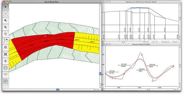
HighRoad Mac v.6.3.2005
HighRoad is a software package that lets you design roads as you always have - graphically.
AEC 3D Culverts-Pipes v.2.0
AEC 3D Culverts-Pipes is a solution helping civil engineers to quickly design and plan pipe type cross drainage structures for highway, canal projects.
BensPlumbing
BensPlumbing software allows you to find quality plumbing services in Sydney fast. Find help for any of your plumbing problems in and around the Sydney area. All this in this free application, requires no install, has no adware or spyware. Just click, run
HighRoad v.6.3.5
HighRoad is an interactive graphical application for the geometric design of roads and highways. Its intelligent object design and highly intuitive interface allows for fast and flexible design.
HEC-GeoHMS v.5.0.0.72
The Geospatial Hydrologic Modeling Extension (HEC-GeoHMS) has been developed as a geospatial hydrology toolkit for engineers and hydrologists with limited GIS experience.